Rajasthan climatedry to subhumid monsoon climateTo the west of Aravali, there is a climate with low rainfall, high daily and annual temperature variation, low humidity and strong winds. On the other hand, east of Aravali, there is humid arid and sub-humid climate.
Factors affecting climate- Latitudinal position, distance from sea level, height from sea level, position and direction of Aravalli mountain ranges etc.
Main features of Rajasthan's climate -
- Predominance of dry and humid climate
- insufficient and uncertain rainfall
- random distribution of rain
- Most rainfall from June to September
- Increased incidence of drought and famine due to variability and deficiency of rainfall.
RajasthanTropic of CancerIt is situated in the north direction. Hence the statesubtropical zoneLocated in. OnlyDungarpur and Banswarapart of the districttropical zoneLocated in.
Aravali mountain rangesHas divided Rajasthan into two parts from the point of view of climate. Due to the Aravalli mountain ranges being in line with the direction of monsoon winds, they do not become a hindrance in the path, hence the monsoon winds go straight and are not able to cause rain. Thus, due to the western region being a shadow region of Aravali, it receives less rainfall.
When the Sun shines directly on the Tropic of Cancer, its rays fall directly on Banswara and obliquely on Ganganagar district. of RajasthanAverage annual temperature 37 degree to 38 degree centigradeIs.
Meteorological Observatory Jaipurestablishment of1875of the principality inCentral Public Works DepartmentIt took place in the premises of. This25.10.1947ToJaipur Airport (Sanganer)Was transferred to.Meteorological Centre, Jaipurestablishment ofOctober 1972It was held in a rented building. Thisin 2001Was shifted to its own departmental building, and provided meteorological services to the public of Rajasthan State and the concerned departments of the Central and State Governments like Agriculture, Irrigation, Power, Flood Control, Relief and Rehabilitation, Roadways and Railways etc.
Rajasthan is divided into five parts from the point of view of climate.
- Dry climate region(0-20 cm.)
- Semi-arid climate region (20-40 cm.)
- Sub-humid climate region (40-60 cm.)
- Humid climate region(60-80 cm.)
- Very humid climate region (80-100 cm.)
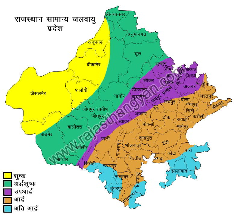
1. Dry region
Area – Jaisalmer, North Barmer, Phalodi, South Ganganagar, Anupgarh and Bikaner and western part of Jodhpur.
Average rainfall – 0-20 cm.
2. Semi-arid climate region
Area – Churu, Ganganagar, Hanumangarh, D. Eastern part of Barmer, Balotra, Jodhpur and Bikaner and western part of Pali, Jalore, Sikar, Nagaur, Didwana Kuchaman and Jhujhunu.
Average rainfall – 20-40 cm.
3. Semi-climatic region
Area - Alwar, Jaipur, Ajmer, Pali, Jalore, Nagaur, Didwana, Kuchaman and eastern part of Jhujhunu and north-western part of Deeg, Dausa, Tonk, Kekri, Bhilwara and Sirohi.
Average rainfall – 40-60 cm.
4. Humid climate region
Area – South Eastern part of Deeg, Bharatpur, Dholpur, Kota, Bundi, Sawai Madhopur, Udaipur, U.P. Salumber, S.E. Tonk and Chittorgarh.
Average rainfall – 60-80 cm.
5. Very humid climate region
Region – S.E. Kota, Baran, Jhalawar, Banswara, Pratapgarh, Dungarpur, S.E. Salumber and Mount Abu areas.
Average rainfall – 60-80 cm.
fact
The hottest months of Rajasthan are May-June and the coldest months are December-January.
Hottest and coldest district of Rajasthan - Churu
The highest daily temperature variation of Rajasthan is in the western region.
District of Rajasthan with highest daily temperature variation - Jaisalmer
The average rainfall in Rajasthan is 57 cm. Whose distribution is 10 to 100 cm. Happens between. Uneven distribution of rainfall, inadequate and uncertain amount causes drought and famine in Rajasthan every year.
The amount of rainfall in Rajasthan decreases from south-east to north-west. Arabian Sea monsoon winds cause adequate rainfall in the southern and south-eastern districts of the state.
Of the total amount of rainfall in the state, 34 percent occurs in the month of July and 33 percent in the month of August.
Highest rainfall at district level - Jhalawar (100 cm.)
Minimum rainfall at district level - Jaisalmer (10 cm.)
The average number of rainy days in Rajasthan is 29.
Highest number of rainy days – Jhalawar(40 days), Banswara(38 days)
Minimum number of rainy days - Jaisalmer(5 days)
The place with highest rainfall in Rajasthan is Mount Abu (120-140 cm). It is here that maximum days of rainfall (48 days) are received.
The number of rainy days increases from northwest to southeast.
Lowest humidity in Rajasthan - in the month of April
Highest humidity in Rajasthan - in the month of August
The highest temperature in Rajasthan is in the month of October.
Place with least rainfall - Sam(Jaisalmer) 5 cm.
Rajasthan by 50 cm. The line divides it into two parts. 50 cm. Rainfall is less in the north-west of the line. Whereas rainfall is more in the south-east.
It is 50 cm. The standard line is considered to be the Aravalli mountain range.
In Rajasthan, the district with highest humidity is Jhalawar and the least humid district is Jaisalmer. The place with highest humidity in Rajasthan is Mount Abu and the lowest humidity is Phalodi (Jodhpur).
The month with highest hailstorm in Rajasthan is March-April and highest hailstorm occurs in the north-eastern region and the district with highest hailstorm is Jaipur.
In Rajasthan, winds blow towards west and south-west.
Highest wind speed - June month
Slow speed of winds - November month
In summer, the air pressure in the western region is less than that in the eastern region.
In summer, hot winds blow from the west which are called Loo. Due to this heat wave, an area of low air pressure is formed here. To compensate for this low air pressure, wind rises rapidly from other areas (from areas with high air pressure) and brings with it dust and soil, this is called a storm.
Highest number of storms – Sriganganagar(27 days)
Minimum number of storms – Jhalawar (3 days)
Dusty spells occur in the northern parts of Rajasthan in the month of June and in the southern parts in the month of May.
In Rajasthan, storms (storm + rain) occur more in the east than in the west.
Humidity
amount of water vapor present in the airis called humidity. relative humidityLowest in March-April and highest in July-Augustit occurs.
loo
Dry and extremely hot winds blowing in the desert areaIt is called heat wave.
Temperature decreases with increasing altitude above sea level. Its normal rate of decline is 165 m. At an altitude of 1 degree Celsius. Is.
of RajasthanDecrease in temperature from north-west to south-eastSight is visible.
Scholars like Koppen, Thornwaite, Trewartha divided the world into climatic regions and expressed their characteristics through abbreviations. Although their classification is not completely meaningful for states like Rajasthan, but their division creates a more common basis. Therefore, on the basis of climatic similarities, Rajasthan is divided into different climatic regions.
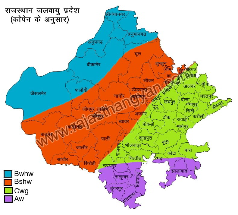
Climate regions according to Köppen
Dr. Vladimir Koppen GermanyWas a scientist who firstin 1918Classified the world's climate. Local according to Köppenvegetationis the best expression of climate, although Köppen usedrainfall and temperatureImportance has also been given to climate because vegetation indirectly depends on rainfall and temperature, hence Köppen has described the climate of Rajasthan in four code words on the basis of vegetation.
In his classification, Köppen has divided the climate into five groups – tropical, dry climate, warm temperate, continental, polar or cold climate group.
- Aw Tropical Wet Climate Region - Dungarpur, Salumber, Pratapgarh, Banswara and Southern Chittor and Jhalawar.
- Bshw semi-arid tropical dry climate region - area west of Aravali
- Bwhw tropical dry climate region - Jaisalmer, Phalodi, Bikaner, Anupgarh, Sriganganagar, Hanumangarh and some areas of Churu district.
- Cwg sub-humid climate region - part of eastern and central Rajasthan east of Aravalli.
Climate regions according to Thornvet
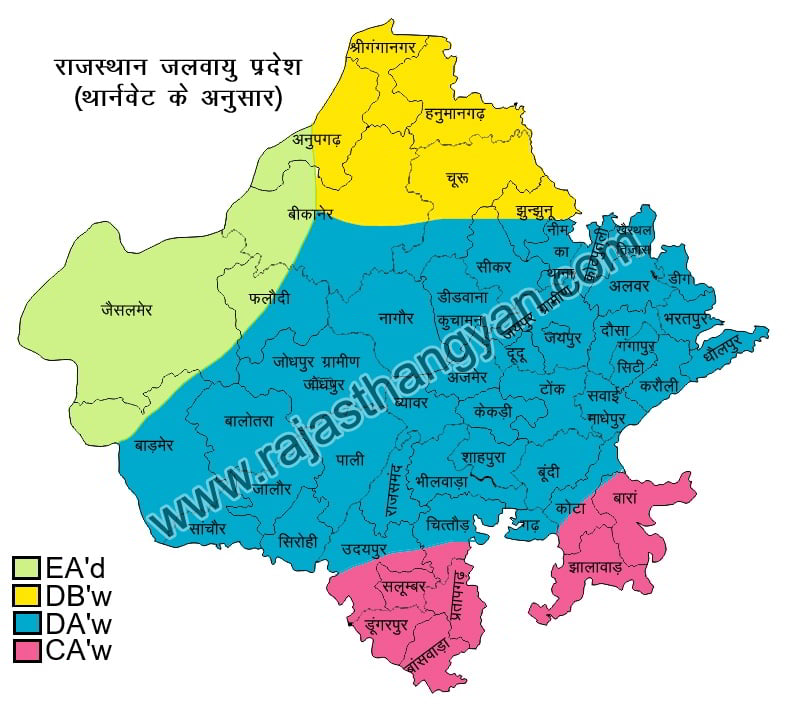
Thornthwaite's climate classificationTranspiration, vegetation, evaporation amount, rainfall and temperatureTook basis.Thornvet's climate classification is more valid in RajasthanIs.
- CA'w or subhumid climate region
- DA' w or hot humid climate region
- DB'w or semi-arid climate region
- EA'd or hot dry tropical desert climate
Climate region according to Trivartha
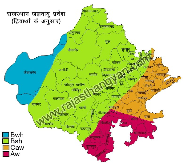
Pro. Trivarthi saidBy modifying Köppen's classificationA more comprehensible, simple, understandable and consistent classification was presented which is as follows.
- Aw tropical wet climate region
- Bsh tropical and semi-tropical steppe-like climate region
- Bwh desert or dry climate region
- Caw semi-tropical humid climate region
Rajasthan has been divided into the following ten climatic regions from the agricultural point of view.
- dry western plains
- Irrigated North Western Plains
- dry partially irrigated western plains
- terminal flow
- Luni Basin
- Eastern Plains(Bharatpur, Dholpur, Karauli districts)
- wet dry climate region
- sub-humid climate region
- humid climate region
- extremely humid climate region
agro-climatic region
seasons
After studying the climate in Rajasthan, three types of seasons are found:-
- Summer: (March to mid-June)
- Rainy season: (mid-June to September)
- Winter: (November to February)
summer season
Summer season in Rajasthan lasts from March to mid-June. It experiences maximum heat in the months of May and June. Due to excessive heat the moisture in the air gets lost. As a result the air becomes lighter and goes up. Therefore, an area of low air pressure is formed in Rajasthan, as a result, air from high air pressure moves faster towards low air pressure, due to which storms continue to flow in summer.
rainy season
The rainy season in Rajasthan is from mid-June to September.
Rajasthan receives rainfall from 3 types of monsoons.
1. Monsoon of Bay of Bengal
This monsoon in Rajasthaneastern directionEnters from. Monsoon winds enter from the eastern direction.EasternersThis monsoon is known asHighest rainfall in RajasthanThis monsoon makes RajasthanNorthern, North-Eastern, South-Eastern regionsIt rains in.
2. Arabian Sea monsoon
This monsoon of Rajasthansouth-west directionThis monsoon enters Rajasthan fromunable to rain muchbecause itparallel to the Aravali mountain rangeSlip out. The extension of Aravali mountain range in Rajasthan is from south-west to north-east. If the extension of Aravali in the state was from north-west to south-east, then Rajasthan would have received maximum rainfall in the area.
in rajasthanThe monsoon of the Arabian Sea first enters
3. Mediterranean Monsoon
This monsoon in Rajasthanwestern directionEnters from. Due to entry from western direction this monsoonMonsoon of Western DisturbancesKnown by the nickname of. This monsoon in RajasthanRain in North-West Regionit occurs. This monsoon mainlywinter rainDescribes winter rainfall in local languageMawaththis is called rainMost beneficial for wheat cropit occurs. these raindropsGolden DropsKnown by the sub-name of.
winter season
in rajasthanwinter season from november to februaryit occurs. in these four monthsMost cold in the month of JanuaryIt rains in the north-western part of Rajasthan due to cyclones originating in the Mediterranean Sea in winter season. Which is called "Mawat/Mawath". This rain occurs in the month of Magha. Winter Rain Mavat is also known as – Golden Drop (Amrit Bude). It is beneficial for Ravi crop.
Winds in the state generally blow towards west and north-west.
Rain
in rajasthanMost rainfall comes from south-west monsoon winds.occurs andSecond place monsoon of Bay of Bengal, Third place monsoon of Arabian Sea, The last place belongs to the monsoon of the Mediterranean Sea.
names of storms
coming from the north- Uttara, Uttarad, Dharod, Dharau
coming from the south- Lakau
coming from the east- Purvaiyan, Purvai, Purva, Aaguni
coming from the west- Pichwai, Pachhau, Pichwa, Aathuni.
Other
from the middle of the north-east- Sanjeri
from the middle of the east-south- rag / eagle
from the center of the south-west- sea/sea
from the north-west- Surya
Dry
dry oneunusual and prolonged dry seasonWhich creates obvious water imbalance in a particular area. Apart from the uncertainty of monsoon, unscientific management of agriculture can also be a responsible factor for drought.Three conditions of ‘drought’Are-(i) Seasonal drought:in a large area75% less rainfall than expectedThe situation arising when it happens.
Based on rainfall deficiency (RD) it can be further classified into three categories.RD > 50% - severe drought25% ≤ RD ≤ 50% - moderate drought RD < 25% - drought
**(ii) Water drought:When the duration of 'meteorological drought' becomes longer, this situation occurs due to drying up of water areas like rivers, ponds, lakes.(iii) Agricultural drought:**In this situation, if the rainfall is much less than the required rainfall for the crop, the soil moisture is insufficient for crop growth.
daily speed/rotation speed
earth on its axis23 1/2 degreesIs inclined. It moves from west to east on its axis.1610 km/hat the speed of23 hours 56 minutes and 4 secondsCompletes one cycle in. this speedrotational speed or daily speedIt is said that because of thisday nightAre there.
annual speed/rotational speed
to the earthrevolution of the sunin doing365 days 5 hours 48 minutes 46 secondslooks like thisEarth's annual speed or rotation speedThey say. the time it takessolar yearIt is said. on earthseasonal change, due to its tilt on its axis and the change in its position relative to the Sun, i.e. due to its annual motion. Due to annual movement, days and nights on Earth become shorter and longer.
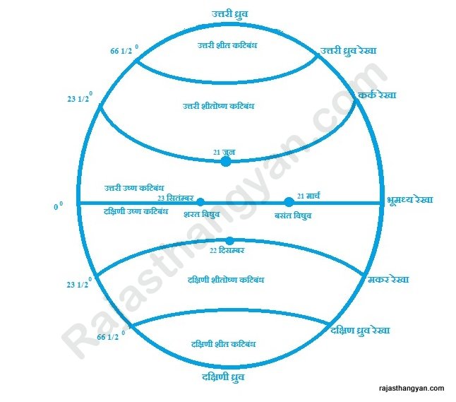
during the Earth's rotation21st March and 23rd SeptemberToThe sun's rays fall directly on the equatoras a resultThe duration of day and night is equal all over the earthit occurs.
equinox
When the sun's rays fall straight on the equatorIf so, this situation is called equinox. There are two equinoxes in a year.
Spring equinox occurs on March 21 and autumn equinox occurs on September 23.
ion
23 1/20 north latitudeFrom23 1/20 south latitudeOf**The central part of the earth where the sun's rays shine directly at some point in the year is called ion.**There are two of them.
Northern Ion (Uttarayan)- Between 0 latitude and 23 1/20 north latitude.
Dakshinayan (Dakshinayan)- Between 0 latitude and 23 1/20 south latitude.
solstice
where ion ends. these are two
End of Uttarayan(Uttaryanant)- At 23 1/20 north latitude/Tropic of CancerEnd of northern ion on June 21It happens.
end of southern ion- At 23 1/20 south latitude/Tropic of CapricornDakshinant on 22 DecemberIt happens.
During the Earth's rotation, on June 21, the Sun's rays remain perpendicular on the Tropic of Cancer, as a result, in the Northern Hemisphere, days are long and nights are short and it is summer, whereas in the Southern Hemisphere, due to the Sun's rays falling obliquely, the days are short and nights are long and autumn.
fact
Longest day in the Northern Hemisphere - June 21
Southern Hemisphere's longest night - June 21
Northern Hemisphere's shortest night - June 21
Shortest day in the Southern Hemisphere - June 21
During the Earth's rotation, the Sun's rays remain perpendicular on the Tropic of Capricorn on December 22, as a result, in the Southern Hemisphere, days are long, nights are short and it is summer, whereas in the Northern Hemisphere, due to the oblique fall of the Sun's rays, days are short, nights are long and it is autumn.
fact
Southern Hemisphere's longest day - December 22
Northern Hemisphere's longest night - December 22
Shortest night in the Southern Hemisphere - 22 December
Shortest day in the Northern Hemisphere - 22 December
belt
land area between any two latitudesIs called the zone.
Gore
land area between any two longitudesIs called gore.
India is situated in two regions.
tropical and temperate zones
Rajasthan is actually located in the subtropical zone, close to the tropical zone.
monsoon
Origin of the word monsoonArabic languageOfMoussinIt is from the word. which literally meansWind directions in a particular seasonIt happens.
Summer/Southwest Monsoon
In summer, when the sun's rays fall directly on the northern hemisphere. So a low pressure area is formed here. Whereas in the Southern Hemisphere, due to slanting of the sun's rays, it is winter and the air pressure remains high. Therefore winds blow from the Southern Hemisphere to the Northern Hemisphere.
Due to India's peninsular location, these monsoon winds coming from the south-west get divided into two branches.
1. Arabian Sea Branch 2. Bay of Bengal Branch
The Arabian Sea branch of monsoon becomes active for the first time in India.. on average1 JuneToMalabar Coast KeralaBut the Arabian Sea branch of summer monsoon is active.
Note
in indiasummer monsoonfirst of all**Andaman Nicobar Islands (Great Nicobar, Indira Point)**But it is activated.
In Rajasthan, only the Arabian Sea branch of summer monsoon becomes active first.
Most of the rainfall in India and Rajasthan comes from the Bay of Bengal branch of summer monsoon.
winter monsoonFromCoromandel Coast Tamil NaduIt rains here. The country that receives maximum rainfall from winter monsoon is China.
fact
The hottest place in the world - Al-Azizia (Libya) Sahara Desert
India's hottest state - Rajasthan
Hottest place in India - Phalodi (Jodhpur)
Hottest district of Rajasthan – Churu
Hottest place of Rajasthan - Phalodi (Jodhpur)
Coldest place in the world – Bakhoyansa (Russia)
India's coldest state - Jammu and Kashmir
Coldest place in India - Loh(-46)
Coldest district of Rajasthan - Churu
Coldest place in Rajasthan - Mount Abu (Sirohi)
Wettest place in the world - Mawsynram (Meghalaya) India
The wettest state of India - Kerala
Wettest place in India - Mawsynram (Meghalaya)
The most humid district of Rajasthan – Jhalawar
Wettest place in Rajasthan - Mount Abu
World's rainiest place - Mosinram (Meghalaya)
Rainiest place in India - Mosinram (Meghalaya)
India's rainiest state - Kerala
Rainiest place in Rajasthan - Mount Abu
Rainiest district of Rajasthan – Jhalawar
World's driest place - Wakhoyansa
The driest state of India - Rajasthan
Dryest place in India - Leh (Jammu and Kashmir)
The driest district of Rajasthan - Jaisalmer
Dryest places of Rajasthan - Sam (Jaisalmer) and Falaud (Jodhpur)
Lowest rainfall place in the world – Bakhoyans
State with least rainfall in India – Punjab
Lowest rainfall place in India – Leh
District with least rainfall in Rajasthan – Jaisalmer
Place with least rainfall in Rajasthan - Sam (Jaisalmer)
India's state with highest temperature difference - Rajasthan
District of Rajasthan with highest temperature variation (annually) – Churu
District of Rajasthan with highest temperature difference (daily) - Jaisalmer
Vegetated area of Rajasthan - Sam (Jaisalmer)
The cold wave that prevails in Rajasthan due to Siberian cold air and Himalayan snow is called - winter.
Hot winds blowing in the Thar Desert in summer - Loo
Most dusty storms occur in Rajasthan - in Ganganar.
Frost in Rajasthan – Frost occurs in the southern and south-eastern parts due to extreme cold.
Heavy rain accompanied by strong winds in South Rajasthan - Cyclonic rain
Gateway of Monsoon in Rajasthan – Jhalawar and Banswara
District with highest rainfall disparity in Rajasthan – Barmer and Jaisalmer
The district with least disparity of rainfall in Rajasthan – Banswara
In which district of Rajasthan does the sun's rays fall directly on 21st June?
Which district of Rajasthan gets the sun's rays on 22 December - Shri Ganganagar
The climate of Rajasthan is – sub-tropical.
Mawath
Due to Western Disturbance/Mediterranean Ocean Disturbance in winterThe rainfall that occurs in the northern plains of India is called Mavath.
Main reason for Mavath -jetstream
Jetstream - All Over the Earthwinds blowing from west to east in the troposphere.
Mawath is very useful for Rabi crop. That's why it is called golden drops or golden drops.
important facts
nor'wester - Chhota Nagpur PlateauBut the winds that blow during summer are called nor'wester. It affects the states of Bihar and Jharkhand.
When Nor'wester winds move eastwards and reach the state of West Bengal, they are called Kaal Vaishali. And when these winds move further towards the east and reach the state of Assam, there is a rainfall of 50 cm. It rains. This rain is very useful for tea cultivation, hence it is called tea rain or tea shower.
Mango Shower- The pre-monsoon rain that occurs in the states of Tamil Nadu, Kerala and Andhra Pradesh, which ripens the mango crops here, is called Mango Shower.
cherry blossom- The pre-monsoon rain in the state of Karnataka, which is very useful for the Kahwa crop here, is called cherry blossom or shower of flowers.
Monsoon disruption- The time between the monsoon rains at one place and the next rain at the same place is uncertain, this is called the irregularity of the monsoon.
monsoon burst- During the summer monsoon in South India, the first heavy rainfall of the monsoon along with strong winds and lightning along with thunder and lightning on the Malabar coast of Kerala is called burst of monsoon.
Rain region and rain shadow region
but in a phased manner- It is a marshy water current which is active during the summer monsoon in the Pacific Ocean to the west of the South American continent, due to which the Indian monsoon weakens. And a situation of scanty rainfall and drought arises in India and neighboring countries.
La Nino- This is a cold water current that originates in the north-east of the Australian continent, opposite to El Nino. This increases the strength of the Indian monsoon and creates a situation of excessive rainfall in India and neighboring countries.
perihelion and aphelion
perihelion- Event of shortest distance (1470 lakh km) between Sun and EarthOccurs on 3rd January and is called Upsaur.
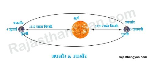
Upsaur - **Event of maximum distance between Sun and Earth (1510 lakh km)**The one which occurs on 4th July is called Apsaur.
Start Quiz!