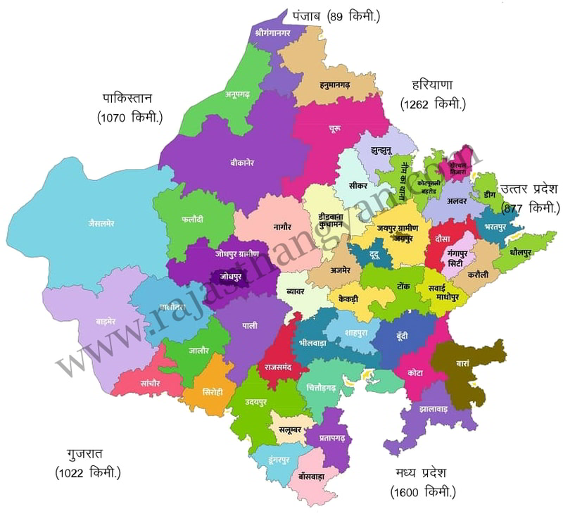
Rajasthan Border
Subject: Rajasthan Geography
Sample Practice Questions
Question 1: राजस्थान के निम्नलिखित में से कौन-से ज़िले पाकिस्तान अंतर्राष्ट्रीय सीमा को छूते हैं?a. जोधपुर b. बीकानेरc. जैसलमेर d. श्री गंगानगर
- a, c और d
- a, b और d
- b, c और d
- b और c
Explanation: बीकानेर, जैसलमेर, श्री गंगानगर पाकिस्तान सीमा (रेडक्लिफ लाइन) को छूते हैं। जोधपुर सीमा को नहीं छूता (यह आंतरिक जिला है)।
Question 2: सूची-I को सूची-II से सुमेलित करें : सूची-I (जिला)सूची-II (सीमा)(a) जालोर(i) उत्तर प्रदेश(b) श्री गंगानगर(ii) गुजरात(c) भरतपुर(iii) मध्य प्रदेश(d) बाँसवाड़ा(iv) पंजाब
- (a)-(ii), (b)-(iv), (c)-(iii), (d)-(i)
- (a)-(i), (b)-(ii), (c)-(iii), (d)-(iv)
- (a)-(iv), (b)-(iii), (c)-(ii), (d)-(i)
- (a)-(ii), (b)-(iv), (c)-(i), (d)-(iii)
Explanation: जालोर → गुजरातश्री गंगानगर → पंजाबभरतपुर → उत्तर प्रदेशबाँसवाड़ा → मध्य प्रदेश
Question 3: निम्नलिखित में से कौन-से राज्य राजस्थान के उत्तर-पूर्व में स्थित है -
- हरियाणा और गुजरात
- पंजाब और मध्य प्रदेश
- हरियाणा और उत्तर प्रदेश
- गुजरात और उत्तर प्रदेश
Explanation: राजस्थान पांच राज्यों के साथ अन्तर्राज्यीय सीमा बनाता है। यह उत्तर में पंजाब, उत्तर-पूर्व में हरियाणा, पूर्व में उत्तर प्रदेश, दक्षिण-पूर्व में मध्यप्रदेश एवं दक्षिण में गुजरात के साथ अन्तर्राज्यीय सीमाएं बनाता है।
Question 4: निम्नलिखित में से राजस्थान का कौन-सा क्षेत्र हरियाणा से अपनी सीमा साझा नहीं करता है - (निम्न में से सबसे उपयुक्त विकल्प चुनें)
- हनुमानगढ़
- दौसा
- सीकर
- अलवर
Explanation: राजस्थान के 8 जिलों (हनुमानगढ़, चूरू, झुंझुनू, सीकर, कोटपूतली बहरोड,खेरथाल तिजारा, अलवर, डीग) की सीमा हरियाणा के 7 जिलों(सिरसा, फतेहबाद, हिसार, भिवाणी, महेन्द्रगढ़, रेवाडी, मेवात) से लगती है। हरियाणा के साथ सर्वाधिक सीमा हनुमानगढ़ की लगती है। हरियाणा सीमा पर क्षेत्रफल में बड़ा जिला चुरू है।
Question 5: निम्नलिखित में से राजस्थान का कौन-सा स्थान अंतर्राष्ट्रीय सीमा के सबसे करीब है -
- फलोदी
- पोखरण
- तनोट
- किशनगढ़
Explanation: राजस्थान की अंतर्राष्ट्रीय सीमा पाकिस्तान के साथ लगभग 1,070 किमी लंबी है, जो मुख्य रूप से जैसलमेर, बाड़मेर, बीकानेर और गंगानगर जिलों से सटी हुई है। तनोट (जैसलमेर जिला) सीमा से सबसे निकट है।
Question 6: राजस्थान का वह जिला जो पाकिस्तान के साथ सबसे छोटी अंतर्राष्ट्रीय सीमा साझा करता है, है:नीचे दिए गए विकल्पों में से सबसे उपयुक्त उत्तर का चुनाव करें :
- गंगानगर
- जैसलमेर
- बाड़मेर
- बीकानेर
Explanation: रेडक्लिफ रेखा के साथ राजस्थान की कुल सीमा 1070 कि.मी. है। जो राजस्थान के पांच जिलों से लगती है।श्री गंगानगर - 210 कि.मी.बीकानेर - 168 कि.मी.जैसलमेर - 464 कि.मी.बाड़मेर - 228 कि.मी.
Question 7: राजस्थान का, निम्नलिखित में से कौन-सा जिला पाकिस्तान के साथ सीमा साझा नहीं करता है -
- बीकानेर
- फलोदी
- श्रीगंगानगर
- बाड़मेर
Explanation: राजस्थान-पाकिस्तान सीमा (लगभग 1070 किमी) चार जिलों से साझा होती है: श्रीगंगानगर, बीकानेर, जैसलमेर और बाड़मेर। फलोदी सीमा पर नहीं है। यह आंतरिक क्षेत्र में स्थित है।
Question 8: राजस्थान अपनी सीमा निम्नलिखित में से किस राज्य/संघ राज्य-क्षेत्र के साथ साझा करता है -
- महाराष्ट्र
- दिल्ली
- हिमाचल प्रदेश
- पंजाब
Explanation: राजस्थान की सीमा लगती है: पंजाब, हरियाणा, उत्तर प्रदेश, मध्य प्रदेश, गुजरात
Question 9: राजस्थान का निम्नलिखित में से कौन-सा क्षेत्र, अंतर्राष्ट्रीय सीमा पर स्थित है -
- चूरू
- राजसमंद
- भीलवाड़ा
- बीकानेर
Explanation: राजस्थान की कुल स्थलीय सीमा की लंबाई 5920 किमी. है। इसमें से 1070 किमी. अन्तर्राष्ट्रीय सीमा है जो पाकिस्तान के साथ लगती है। और 4850 किमी. अन्तर्राज्यीय है जो भारत के पांच राज्यों - पंजाब, हरियाणा, उत्तर प्रदेश, मध्यप्रदेश, गुजरात के साथ लगती है।अंतर्राष्ट्रीय सीमा पर स्थित जिलें - 4(बाड़मेर, जैसलमेर, बीकानेर व श्रीगंगानगर)
Question 10: भारत का कौन-सा निम्नलिखित राज्य राजस्थान के साथ अपनी सीमा साझा नहीं करता है -
- पंजाब
- उत्तर प्रदेश
- हरियाणा
- महाराष्ट्र
Explanation: राजस्थान की सीमाएँ पंजाब, हरियाणा, उत्तर प्रदेश, मध्य प्रदेश, गुजरात और पाकिस्तान से लगती हैं। महाराष्ट्र इसकी सीमा से नहीं जुड़ा है। राजस्थान की कुल स्थलीय सीमा की लंबाई 5920 किमी. है। इसमें से 1070 किमी. अन्तर्राष्ट्रीय सीमा है जो पाकिस्तान के साथ लगती है। और 4850 किमी. अन्तर्राज्यीय है जो भारत के पांच राज्यों - पंजाब, हरियाणा, उत्तर प्रदेश, मध्यप्रदेश, गुजरात के साथ लगती है।